


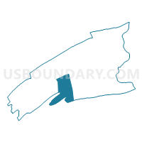
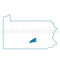
TYRONE TWP Voting District, Perry County, Pennsylvania
About
Outline

Summary
| Unique Area Identifier | 661973 |
| Name | TYRONE TWP Voting District |
| County | Perry County |
| State | Pennsylvania |
| Area (square miles) | 35.88 |
| Land Area (square miles) | 35.67 |
| Water Area (square miles) | 0.21 |
| % of Land Area | 99.42 |
| % of Water Area | 0.58 |
| Latitude of the Internal Point | 40.29769130 |
| Longtitude of the Internal Point | -77.36107250 |
Maps

Graphs
Select a template below for downloading or customizing gragh for TYRONE TWP Voting District, Perry County, Pennsylvania


Neighbors
Neighoring Voting District (by Name) Neighboring Voting District on the Map
- LANDISBURG Voting District, Perry County, PA
- LOWER FRANKFORD TWP Voting District, Cumberland County, PA
- LOWER MIFFLIN TWP Voting District, Cumberland County, PA
- NORTH EAST MADISON TWP - SANDY HILL DISTRICT, Perry County, PA
- SAVILLE TWP Voting District, Perry County, PA
- SOUTH WEST MADISON TWP - MADISON TOWNSHIP Voting District, Perry County, PA
- SPRING TWP Voting District, Perry County, PA
- UPPER FRANKFORD TWP Voting District, Cumberland County, PA
Top 10 Neighboring County Subdivision (by Population) Neighboring County Subdivision on the Map
- Saville township, Perry County, PA (2,502)
- Spring township, Perry County, PA (2,208)
- Tyrone township, Perry County, PA (2,124)
- Upper Frankford township, Cumberland County, PA (2,005)
- Lower Mifflin township, Cumberland County, PA (1,783)
- Lower Frankford township, Cumberland County, PA (1,732)
- Southwest Madison township, Perry County, PA (999)
- Northeast Madison township, Perry County, PA (786)
- Landisburg borough, Perry County, PA (218)
Top 10 Neighboring Place (by Population) Neighboring Place on the Map
Top 10 Neighboring Unified School District (by Population) Neighboring Unified School District on the Map
Top 10 Neighboring State Legislative District Lower Chamber (by Population) Neighboring State Legislative District Lower Chamber on the Map
Top 10 Neighboring State Legislative District Upper Chamber (by Population) Neighboring State Legislative District Upper Chamber on the Map
Top 10 Neighboring 111th Congressional District (by Population) Neighboring 111th Congressional District on the Map
Top 10 Neighboring Census Tract (by Population) Neighboring Census Tract on the Map
- Census Tract 130, Cumberland County, PA (6,824)
- Census Tract 305.02, Perry County, PA (5,946)
- Census Tract 306.01, Perry County, PA (4,844)
- Census Tract 306.02, Perry County, PA (3,038)